Note: This article is an exact translation of the original article written in the Slovak language on August 2010 (with the exception of replacing Slovak realia with the US/UK ones and adding the imperial units data), thus unaffected by the Libya affairs which took place in 2011. Due to the recent mass communication tendency of erasing the positive facts about Libya under col Muammar Gaddafi's rule (including, e.g., UNESCO removing its link about the project), provable distortion of information appearing in mass media, or losing neutral point of view (like some articles in Wikipedia), author decided to publish this translation in order to provide neutral, data-driven and fact-based description of the Libya's remarkable project regardless of the global political mood.

One would logically expect the largest and most demanding projects to be accomplished by the most developed or at least the most populated countries of the world, managing adequate resources. There is abundance of information concerning construction of impressive dams, bridges or tunnels in such countries, however, there exists one exception constructed in a technologically neglected part of the world, almost without arousing notice outside its own continent. Honestly - have you ever heard about the Great Man-Made River in the Libyan Sahara yet? The following lines describe this remarkable system built deep inside the Sahara desert.
Small country with big opportunities.
The project was accomplished by a North African country with number of inhabitants comparable to a larger city - Libya, by the full title the Great Socialist People's Libyan Arab Jamahiriya (jamahiriya is a specific form of republic). Project costs exceed USD 27 bln (more than the amount consumed by the Three Gorges Dam in China, the world's largest capacity hydropower station, and significantly more than the price of the Large Hadron Collider, the largest machine in the world). It's noteworthy that these costs were covered by the country's own resources, without any significant loans or debts from international banks or funds. This was enabled by the immense natural resources - estimated oil reserves put the country at the tenth place in the world. Let's have a look at the scientific background and the technical details more closely.
There is more water beneath the Sahara than in the Caspian Sea.
Foremostly, we should say something about the Sahara Desert. In most people's opinion this desert must be a bone-dry area completely depleted of water. Undoubtedly, this part of the world is indeed arid regarding the rainfall (although the driest place in the world is the South American Atacama Desert in Chile). However, the geological surveys in fifties revealed a surprising fact - there lie enormous groundwater reservoirs beneath the surface. This water is locked hundreds of meters deep, beneath vast areas of the eastern parts of Sahara (mostly Libya, Chad, Sudan and Egypt). Geologists call these reservoirs the Nubian Sandstone Aquifer System (geological term "aquifer" means an underground layer saturated with water), which is the world's largest reservoir of fossil water, covering more than 2 million square kilometers (772,000 sq mi) and containing an overwhelming volume of water - estimates lie around 150,000 km3 (36,000 cu mi). That's more than twice the volume of the Caspian Sea! It is also noteworthy that this water originated mostly from the last ice age (therefore, the term "fossil"), and has accumulated in the reservoirs approximately 1 million - 10 000 years ago, when the climate was generally wet, rich in rainfall, and sufficient for maintaining a complex river system. Due to the steep decrease in rainfall since the end of the ice age these reservoirs are not being renewed anymore.

Image 1: Sahara has not always been such an arid country at all. Remnants of an ancient lake existing there between 750 thousand and 420 thousand years ago were found in south-western part of Libya (Fezzan). Scientists named it Megafezzan - with a surface area of 130 thousand km2 (50,193 sq mi) it is definitely worth of bearing its name (compare with the largest of the Great Lakes - Lake Superior, with the surface of 82,000 km2 [31,700 sq mi]). Local sediments are an extraordinary source of information about the climate changes in Sahara during the last 750 thousand years.
Credit: The British Academy
Arid country
Naturally, the knowledge about such immense volumes of drinking water was not left without attention. There are no continuous watercourses in Libya, all the drinking water is obtained from aquifers in the coastal areas and by the sea water desalination. Coastal aquifers, however, suffer from one unfavourable malady - removed water is naturally refilled by the sea water from the nearby Mediterranean Sea. Therefore, salinity of the aquifers constantly increases, reaching 0.7% content of salt recently. Such water is not only unhealthy, but it is not being suitable even for irrigation of agricultural areas, causing salinization of the soil and subsequent crop decrease. Thus, Libya's need for high quality fresh water is fairly urgent. Several scientific studies dealing with various possibilities of fresh water production were conducted, proving the man-made river alternative as the most economic way of avoiding the water crisis.
![]()
Image 2: Amount of water in cubic meters which could be provided for one Libyan dinar, based on scientific research. Studies proved the man-made river being the most economic approach, which provides more than ten times of water for one dinar compared to various alternative technologies (e.g., undersea pipeline from Southern Europe, transport by water tankers, sea water desalination etc).
Credit: The Great Man Made River Authority
Initially, authorities intended to drill the wells directly in the aquifer areas and thought of creating whole new cities and irrigated agricultural areas there. However, due to the necessity of transferring high numbers of inhabitants and building infrastructure in a poorly accessible terrain this possibility was soon abandoned as being economically unfeasible. Therefore, in concordance with a bit reformulated old Arab saying "If Muhammad will not come to the mountain, then the mountain must go to Muhammad", the project of the man-made river of hitherto unprecedented dimensions was decided to be realized in 1983 in order to bring the fresh water from inside the deep desert to the people at the coast. Nevertheless, it was inevitable to overcome several obstacles - considerable distance between the aquifers and the coast, rough desert conditions, elevation differences in the terrain, corrosion of the reinforced concrete, and many more.
Project in numbers
Specially designed excavators bit into the arid desert in 1984, launching the first most demanding phase of the project. It was necessary to build water fields with hundreds of drills (or wells, using the standard "water" terminology) several hundred meters deep, transport pipelines composing from sections made from specially designed prestressed reinforced concrete (the world's largest prestressed pipes) burned into the soil in order to avoid evaporation, large water reservoirs for continuous supply of water during the summer months, pumping stations responsible for transport of water in the pipelines with desired direction and speed, power stations supplying energy for the pumps and wells, two factories producing the pipes, and many more nontrivial tasks.
Generally, five main phases were planned - three of them have been fully completed, the fourth is under construction, and the fifth should be completed until 2025. During the first three phases USD 19.58 bln were invested, the remaining USD 7.5 bln are to be invested within the fourth and fifth phases.
Moreover, five failures of the pipelines occurred during 1999 and 2001. Analysis revealed that they were caused by corrosion of the metal wires in the pipes. Therefore, extensive monitoring of the pipeline net has been developed and implemented, employing sophisticated acoustic detectors. Unexpected failures have not occurred afterwards.
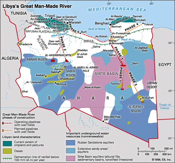
Image 3: Map of Libya showing the structure of the man-made river project and its phases. With an area of 1,759,541 km2 (679,359 sq mi) Libya is slightly larger than Alaska, US, and more than seven times the area of the United Kingdom.
Credit: Encyclopedia Britannica
First phase of the work began in 1984 in the most rough and arid south-eastern region of Libya, water having been transported from the well fields containing 234 drills through 1,600 km (994 mi) long pipeline into two coastal areas. Two reservoirs have storage capacity of 20 million m3 (706 million cu ft) of water. Transport capacity reaches 2 million m3 (70.6 million cu ft) per day. Power consumption: 65 MW. First water reached its destination in 1990.
Second phase brought the water finally to the Tripoli capital - 1,227 km (762 mi) long pipeline in the western part of the country is capable of transporting 2.5 million m3 (88 million cu ft) of water per day and provides inhabitants with water containing more than twenty times less salt than the previous sources.
Third phase extended the first phase pipeline by another 383 kilometers (238 mi) deeper into the desert, where a new well field containing another 300 drills was constructed. Seven new pumping stations transport additional 1.68 million m3 (59.3 million cu ft) of water per day, whilst the whole journey to the final reservoirs takes approximately 9 days.
Fourth phase is of a relatively smaller scale, and will transport quarter of million m3 (8.8 million cu ft) of water per day, using 621 kilometers (386 mi) of pipelines (plus 181 km [112 mi] of pipes within the well field itself), four pumping stations and three reservoirs.
Fifth phase will be the final one connecting the western and eastern transporting systems. With the pipeline being 190 kilometers (118 mi) long, transporting capacity of 0.98 million m3 (34.6 million cu ft) per day, two pumping stations, power consumption 43.6 MW, and one reservoir, it will be a smaller although important sibling of the preceding phases.

Image 4: Miracle of the nature or product of the human skills? Water gushing from one of the 1,116 active drills deep inside the arid desert.
Credit: SNC-Lavalin Company.
Overall parameters of the project are impressive - the man-made river is comparable in size with many natural rivers, and the title "river" is not being exaggerated at all:
| Parameter | Value | Comparison |
| Overall pipeline length |
4,071 km (2,530 mi) transport pipeline without well fields + 1,679.5 km (1,043.6 mi) pipeline connecting the drills within the well fields |
Earth circumference (equatorial): 40,075 km (24,901 mi) Total length of Mississippi: 3,734 km (2,320 mi) Air distance between: |
| Total number of drills / wells in the well fields | 1,116 (excluding inactive drills) | |
| Total transport capacity |
6.5 million m3 (230 million cu ft) of water per day = 75 m3/s (2,650 cu ft/s) |
River Thames (UK), average discharge in London: 65.8 m3/s (2,324 cu ft/s) Rio Grande (US, Texas), average discharge: 40 m3/s (1,475 cu ft/s) |
| Umar Al-Mukhtar reservoir capacity |
24 million m3 (848 million cu ft) |
Jacqueline Kennedy Onassis Reservoir (New York) water volume: 3.8 million m3 (134 million cu ft) |
| Total capacity of the reservoirs |
54,9 million m3 (1.938 bln cu ft) |
|
| Total area of the well fields |
11,927 km2 (4,605 sq mi) |
Area of: Connecticut (US): 14,357 km2 (5,543 sq mi) |
| Total area of the new soil irrigated by the man-made river |
1,300 km2 (501.9 sq mi) |
Irrigated land in the United Kingdom (2003, source : CIA World Factbook): 1,700 km2 (656 sq mi) |
| Total costs | USD 27 bln |
World's largest capacity hydropower station (Three Gorges Dam, China) - USD 26 bln |
| Volume of excavations |
250 million m3 (8.83 bln cu ft) |
Excavated earth moved during construction of the Three Gorges Dam - 102.6 million m3 (3.62 bln cu ft) |
| Total weight of cement used |
7 million tonnes 7.72 million tons (US) 6.89 million tons (UK) |
Weight of the Great Pyramid in Giza - app. 6.5 million tonnes (7.17 mln US tons, 6.39 mln UK tons) Volume of concrete used for the Three Gorges Dam - 200,000 m3 [7.06 million cu ft] (weight app. 480,000 tonnes, 529,000 US tons, 472,000 UK tons) |
| Total length of prestressed wire |
6 million km (3.73 million mi) |
150 times the equatorial circumference of the Earth |
| Average depth of the wells | more than 500 meters (1,640 ft) | |
| Number of transported pipes | 500,000 |
Project in pictures

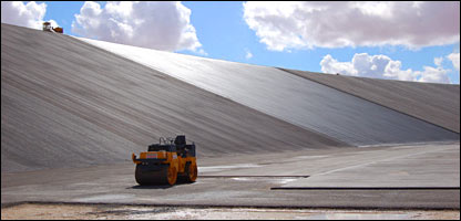
Special heavy equipment capable of manipulating with objects weighting 86 tonnes (84.6 UK tons, 94.8 US tons) was needed.
Credit: Halcrow

Hydraulic excavator is able to ditch a trench sufficient for laying a 4 meter (13.1 ft) diameter pipe.
Credit: Galen Frysinger
Special transporters were needed for transporting the pipes weighting 86 metric tonnes and measuring 4 meters (13.1 ft) in diameter and 7.5 meters (24.6 ft) in length through the desert.
Credit: Galen Frysinger
Fleet of more than one hundred transporters has altogether travelled a distance equal to the distance between the Earth and Sun.
Credit: Green Prophet

Pipes being prepared for installation.
Credit: Halcrow

Excavator during the work in the middle of nowhere.
Credit: water-technology.net

Crane with lifting capacity of several hundreds of tonnes is laying the pipelines into the ground.
Credit: UNESCO

The trench is dug 7 meters (23 ft) deep into the desert ground.
Credit: National Geographic

Laying the pipeline into the excavated trench.
Credit: 7-Technologies A/S
Twists are also part of the life.
Credit: The McGraw-Hill Companies, Inc.
Umar Al-Mukhtar reservoir under construction.
Credit: BBC
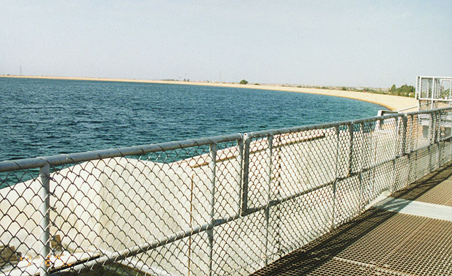
Umar Al-Mukhtar reservoir after the completion. It is the largest water reservoir of the project providing constant supply of water during the whole year.
Credit: Galen Frysinger

Satellite image of the Umar Al-Mukhtar reservoir.
Credit: Google Imagery,
coordinates 25.45556°N,+21.60083°E

Although the initial concept of an agricultural land inside the desert was abandoned, there were several exceptions. These green circles of irrigated crops are visible by the naked eye even form space.
Credit: University of California, Berkeley

Agricultural land inside the desert as viewed from space.
Credit: University of California, Berkeley

These high-pressure vessels with futuristic design are part of the project as well.
Credit: Socomenin company
Project within context
Project and the invested effort, skills, and coordination of work as well, deserve admiration and respect, as any other achievement of our mankind does. Especially with respect to the fact that only few coutries have ever invested such percentage of their national income into improvement of its people's living conditions as Libya has. It is one of the few countries where the natural resources were used directly for increasing people's living standard without encumbering the country with debts or loans - in spite of the indisputable political negatives Libya has the highest Human Development Index (HDI=0.755 as of 2010, 53rd place in the world, evaluated by the United Nations based on life expectancy, education and gross domestic product per capita) among all African countries, even higher than some countries within EU and NATO (Bulgaria: 0.743, Turkey: 0.679 as of 2010). That's something undoubtedly worth paying an attention, regardless of all the objections which the western society may have to the specific form of socialism ruling in this Mediterranean country.
However, critical voices have appeared as well - ecologists have objections to draining the nonrenewable water resources (counterargument of the Libyan government is both the volume of the reserves - with the current rate the aquifers in Libya itself will sustain for more than one thousand years - as well as uselessness of leaving the water in aquifers, having negligible value if left untouched). Politicians point out the possible future conflicts among the neighbouring countries due to the reciprocal draining of the aquifers which naturally do not obey the political borders (counterargument of Libya is its panafrican approach and suggested cooperation with the neighbouring countries, which do not use the aquifers yet). International economists in turn criticize growing crops with water obtained in this way would be more expensive than import of foods from abroad - counterargument is the fact that 30% of water is being used for direct household usage, as well as state-of-the-art methods of economical and effective irrigation and, last but not least, the unique advantage of the food self-sufficiency and stable price of the crops obtained by irrigation employing the man-made river.
Summa summarum, this world's largest irrigation project (recognized also by the Guinness World Records in 2008) is a sleeping beauty of the world engineering, which started being timidly posing at international conferences and in media only recently, after refreshment of the Libya relations with the world. Definitely, there is nothing to be ashamed of.
Author: Juraj Kotulič Bunta, Ph.D
Main sources:
UNESCO (site removed after the 2011 affairs, now available via web archive link)
The Great Man Made River Authority (site removed/domain sold, the original one available via web archive link)
- Ak chcete pridať komentáre, tak sa musíte prihlásiť
- prečítané 118291x
-


Unesco site on Internet Archive (web archive)
http://web.archive.org/web/20091112040332/http://www.unesco.org/water/ihp/prizes/great_man/index.shtml